


What are the Oldest Borders in the World?
Discover the oldest borders in the world. And how they continue to divide nations today.

Last week I explored the world’s first borders in my Substack newsletter. From the clay Cuneiform tablets recording Mesopotamian boundary disputes to the hulking stone remnants of Hadrian's Wall; these ancient borders shaped humanity’s modern geopolitical boundaries.
For the most part, however, these early borders are now buried in desert sands, lost beneath muddy fields or consigned behind the protective perspex of museums. They still linger in the collective consciousness of the nations they shaped - how many people in Britain still question if Hadrian’s Wall is the border between England and Scotland, for example? It's not, and never was - and typically, they no longer claim to be ‘national’ boundaries.
So which modern borders can now claim to be the oldest in the world? Which international boundaries have survived the ravages of history and the passing of centuries? Which ancient dividing lines still separate us today? That's the subject of this week’s Substack.
Here are the oldest, contiguous and continuous borders in the modern world.
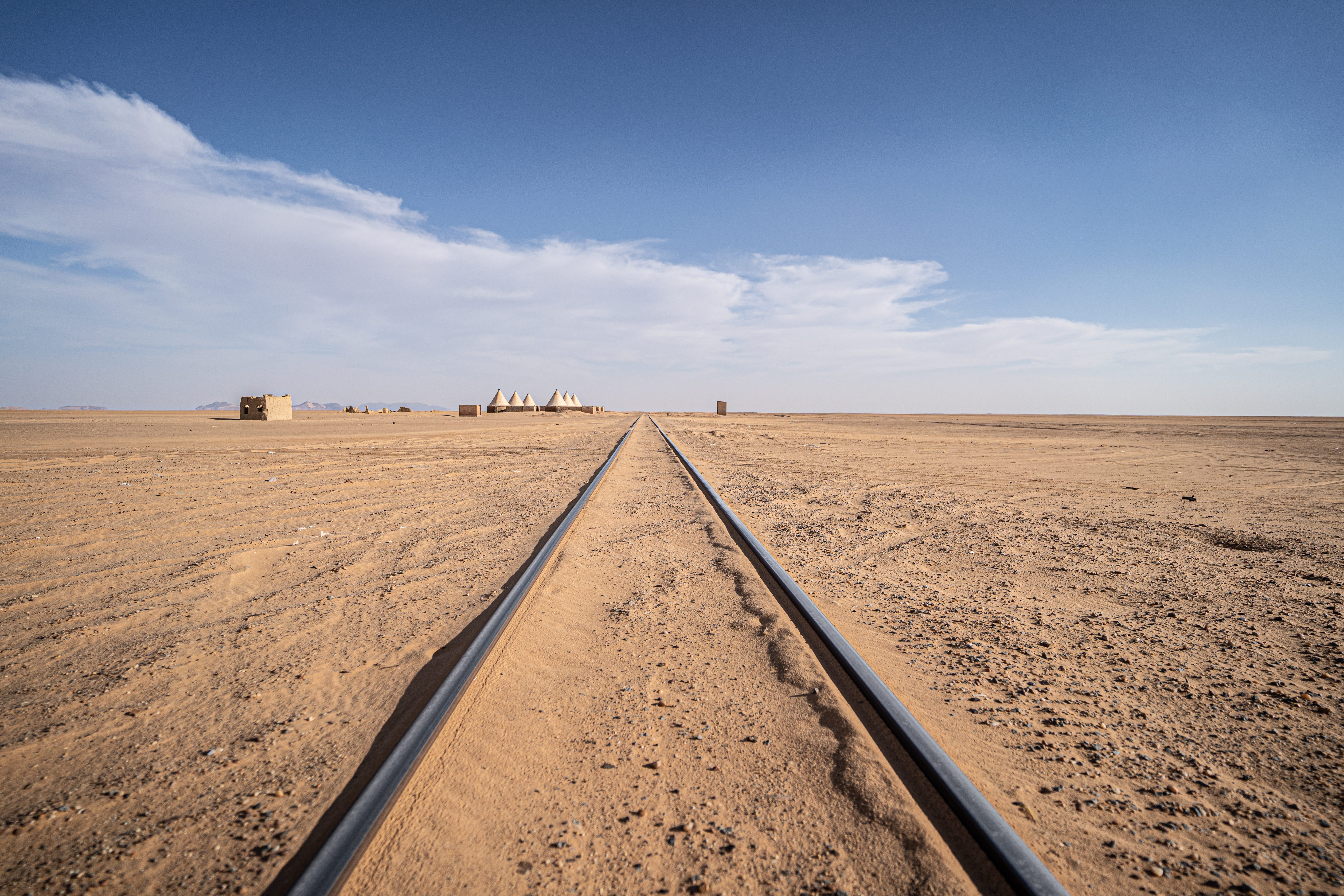
1. The Egyptian-Sudanese Border
You might remember the Egyptian-Sudanese border making an appearance in last week’s Substack. It's back again; because the desert divide between those two North African nations traces its origins right back to the ancient rivalry between the Egyptian Pharaohs and the Nubian Kushite Kingdoms.
The Pharaohs marked their southern frontier with a series of forts built south of the Nile’s First Cataract, eventually pushing as far as Wadi Haifa. This same frontier, roughly following the 22nd parallel, was used again by the Ottoman and British Empires, and the modern border was drawn in 1899 with the signing of an Anglo-Egyptian treaty which turned Sudan into one of the world’s rare Condominiums (it was co-governed by the British Empire and Sudan).
Disputes persist as they have for 4000 years. Notably, both Egypt and Sudan claim ownership over the Halaaib Triangle, a resource-rich area of desert along the border. Peculiarly, neither side claims ownership over Bir Tawil, a trapezoid of land also found on the border.
2. Chinese-Mongolian Border
Clocking in at well over 4000 kilometres in length, the modern Chinese-Mongolian border is the world’s fourth longest. Interestingly, China’s northern frontier has remained remarkably consistent since the earliest segments of what would become the Great Wall of China were raised as early as the 7th Century BCE.
This long frontier marked the dividing line between Chinese dynasties and nomadic steppe tribes for centuries. The Mongols, though, couldn't be stopped by the wall. Genghis Khan conquered China and ruled over the largest contiguous land empire in history.
The Mongol Empire fell, and Chinese dynasties rose and fell too. But the Chinese-Mongolian border remains. After the fall of the Qing Dynasty in 1911, Mongolia declared independence, and the modern border was officially established in 1946 when communist China recognised Mongolian independence. Today, it remains a crucial boundary between two distinct cultures.
3. The Anglo-Scottish Border
The Anglo-Scottish border is one of the oldest national borders in the world, and it’s going to feature heavily in my upcoming book, Borderlands. Formally established by the Treaty of York in 1237, this frontier has been a site of war, rebellion, and shifting allegiances for centuries.
Despite this formal delineation, the Anglo-Scottiah borderlands were fiercely contested for centuries. The Scots frequently raided and invaded England, and the English did the same to Scotland. The borders themselves were home to lawless clans and raiding families—the Border Reivers—who defied both crowns.
Despite the 1603 Union of the Crowns and the 1707 Act of Union, the border remains a cultural and political fault line. Today, the debate over Scottish independence keeps this ancient boundary relevant, proving that even the oldest borders still shape modern history.
4. Portuguese–Spanish Border
The Portuguese-Spanish border, known as the ‘La Raya’ (in English: ‘The Line’), is one of the oldest unchanged borders in the world. Dating back to the Treaty of Alcañices in 1297, this dividing line follows almost the exact same route agreed by medieval kings centuries prior.
While many European frontiers have shifted due to war and diplomacy, Portugal has maintained its independence, and its frontier with Spain, for over 700 years. The border is fascinating for geopolitical addicts like myself. Its long history has produced plenty of cartographical quirks and historical anomalies, including the disputed town of Olivenza/Olivença, which is controlled by Spain but claimed by Portugal.
5. Iran–Iraq Border
The Iran-Iraq border is one of the Middle East’s oldest and most contested frontiers. Shaped by ancient empires, colonial treaties, and modern warfare, it stretches for some 1,599 km (994 miles) along the route of a historically fluid boundary that once separated Persia and Mesopotamia.
In its modern guise, the 1639 Treaty of Zuhab - signed between the Ottoman and Safavid Empires - was the first attempt to formally define this border. However, disputes continued well into the 20th century, particularly over the Shatt al-Arab waterway, a vital trade and oil shipping route. This territorial conflict was a key trigger for the Iran-Iraq War (1980–1988)—one of the bloodiest wars of the 20th century.
Despite post-war agreements, tensions remain, with border skirmishes and political friction persisting. The Iran-Iraq border is a reminder of how history, resources, and identity continue to shape geopolitics in the Middle East.
6. Andorra
And finally, I bring you Andorra, home to one of the oldest and most unusual borders in Europe. Andorra has effectively existed as a tiny buffer state since 1278, when the Paréage Agreement was signed between the Count of Foix (France) and the Bishop of Urgell (Spain). This created a ‘co-principality’, an unusual situation still governing the country today.
Unlike most European borders, Andorra’s has remained largely unchanged, despite wars and empires shifting around it. The principality avoided conquest during Napoleon’s expansion and both World Wars, preserving its independence while maintaining ties with its larger neighbours.
Today, Andorra’s border is completely open, thanks to customs agreements with Spain, France, and the EU. It has become a hub for tax-free shopping and tourism, but its medieval governance system and long-standing neutrality make it a living relic of Europe’s feudal past.
History buffs may note there are several borders that could be considered older than the ones I've included here. Cornish nationalists often claim the River Tamar, the divide between England and Kernow, is one of the oldest national boundaries, dating back to 936 AD. In the Welsh Marches, Offa's Dyke first divided the English and Welsh as far back as the 8th century AD, and Charlemagne delineated the boundary between his Holy Roman Empire and what became Denmark in 811 AD.
However, these boundaries have either changed drastically over time or aren't considered to be national dividing lines anymore. It's subjective though, so let me know in the comments which borders you think I should have included!
Borders in World News
The world continues to be defined by its borders. Here are the border stories that caught my eye this week:
A Federal Europe?
That's the potential geopolitical structure of the future floated by ‘nation.cymru’, a website advocating for Welsh Independence. It's an intriguing model of governance, one in which smaller, independent nation-states (like Wales, Scotland, Catalonia or Basque Country) surrender part of their sovereignty to Europe. Given the rise of independence movements across Europe, and their simultaneous desires to be part of the EU, this could well become a political reality in the future.
Read more:
Kurdistan is investing big to bring in tourists
The United Kingdom’s FCDO recently relaxed its stringent travel guidance for Iraq. That includes Kurdistan, the autonomous region to the north (they even declared independence, unsuccessfully, back in 2017) that's long been a bastion of safety and stability in a conflicted region.
Last year Kurdistan welcomed 1.7 million tourists in the first four months of 2024. The Kurdish government recently unveiled an ambitious goal to welcome 20 million by 2030 There are big investments in hotels, the opening of the new Zagros Mountain Trail for hikers, and the planned construction of a brand new 160-million dollar cable car that's going to be 10 kilometres long.
Now's the time to cross that border and visit Kurdistan!
Danish petition to buy California raises thousands of signatures
My favourite snippet of news this week is the audacious Dansh petition to buy California. I say audacious, but in reality, a petition attracting over 200,000 signatures simply demonstrates the absurdity of Trump's efforts to buy Greenland. The Danes are fighting back, and the Americans should stop and listen!
It's now officially ‘Gulf of America’ on Google Maps
Despite Google claiming they would only be changing the Gulf of Mexico's name on US maps, the tech giant is pandering to Trump already. On my Google Maps (I'm based in the United Kingdom), the name Gulf of America appears in brackets beneath the Gulf of Mexico.
This is peculiar because Google never makes this distinction for other naming disputes (and this Gulf of Mexico/America thing is a naming dispute). The Gulf of Arabia isn't also listed as the Gulf of Persia, for example, or the English Channel doesn't have (La Manche) in brackets beneath it.
Names, maps and cartography formulate our geopolitical views. They're important. That's why I liked one suggestion on BBC Travel last week, recommending that the Gulf of Mexico, if it is renamed, becomes the more encompassing Gulf of the Americas, to recognise all the nations, people and histories it’s shaped.
Tour of the Week
Borderlines is all about exploring the world, so with that in mind, here's my tour of the week.
Untamed Borders. Zagros Mountain Trail.
The Zagros Mountain Trail is Kurdistan's first multi-day hiking trail. And it looks epic. Only opened last year (and still largely un-waymarked), this thru-hike takes you deep into the heart of the Zagros Mountains, a natural frontier which sweeps across Iran and Iraq.
The trail follows old shepherds’ paths and ancient pilgrimage routes and is just one example of how Kurdistan is opening its border to the world as an alternative tourist destination. The trail itself is rather raw, but luckily, adventure travel company Untamed Borders or organising a multiday guided hike this April.
More here: https://untamedborders.com/itinerary/trek-kurdistan-zagros-mountain/
Where am I now?
I landed in Jordan last Friday after an early morning start on a Wizz Air flight from London Luton. It was slightly daunting when the Captain announced over the intercom that we had to put our seat belts on when flying over Israeli territory. Jordan has since proven to be a bastion of Middle Eastern hospitality, however, and I’m excited to bring you stories from Amman, the capital, in the next newsletter.
I'll be here in Jordan for the next two weeks, first exploring Amman’s unusually multicultural roots before following the Hejaz Railway (or what remains of it) south to Wadi Rum.
From there, I'm still debating the exact route, but I'll be driving the King’s Highway and the Dead Sea Highway before venturing into the basalt landscapes of the Eastern Deserts between the Iraqi, Syrian and Saudi borders. Follow my Instagram for real-time (more or less!) stories and check back here for updates next week.
Join the Borderlines Community
Join me on my quest to explore the world through its borders and boundaries.
Be part of a community of travel enthusiasts who love exploring the world’s cartographic curiosities and geopolitical oddities. Read more on Travel Tramp.
This newsletter is a work in progress, so please let me know what you enjoy reading or what you’d like to see in the comments section!
Amazing. Love that.